
Pawling Nature Reserve topographic map
Interactive map
Click on the map to display elevation.
About this map
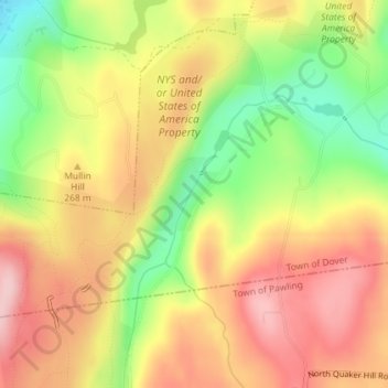
Name: Pawling Nature Reserve topographic map, elevation, terrain.
Average elevation: 252 m
Minimum elevation: 141 m
Maximum elevation: 342 m
Other topographic maps
Click on a map to view its topography, its elevation and its terrain.
Village of Rhinebeck
United States > New York > Dutchess County
Village of Rhinebeck, Town of Rhinebeck, Dutchess County, New York, United States
Average elevation: 55 m
Hurd Corners
United States > New York > Dutchess County > Town of Pawling
Hurd Corners, Town of Pawling, Dutchess County, New York, 12564, United States
Average elevation: 199 m
Town of Rhinebeck
United States > New York > Dutchess County > Town of Rhinebeck
Town of Rhinebeck, Dutchess County, New York, United States
Average elevation: 66 m
Beacon
United States > New York > Dutchess County > Beacon > Beacon
Beacon, Dutchess County, New York, 12508, United States
Average elevation: 91 m
Poughquag
United States > New York > Dutchess County > Beekman > Poughquag
Poughquag, Beekman, Town of Beekman, Dutchess County, New York, 12570, United States
Average elevation: 164 m