
Mount Cole topographic map
Interactive map
Click on the map to display elevation.
About this map
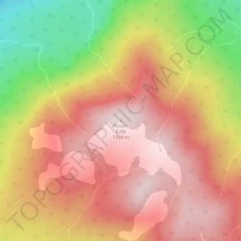
Name: Mount Cole topographic map, elevation, terrain.
Average elevation: 1,480 m
Minimum elevation: 1,132 m
Maximum elevation: 1,699 m
Other topographic maps
Click on a map to view its topography, its elevation and its terrain.
Chimney Rock
Canada > British Columbia > Squamish-Lillooet Regional District > Area B (Cayoosh/Pavilion)
Chimney Rock, Area B (Cayoosh/Pavilion), Squamish-Lillooet Regional District, British Columbia, Canada
Average elevation: 1,506 m