
Pennington County topographic map
Interactive map
Click on the map to display elevation.
About this map
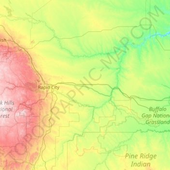
Name: Pennington County topographic map, elevation, terrain.
Location: Pennington County, South Dakota, United States (43.68494 -104.05545 44.50829 -102.00183)
Average elevation: 960 m
Minimum elevation: 553 m
Maximum elevation: 2,186 m
Pennington County is located on the west line of South Dakota. Its west boundary line abuts the east boundary line of the state of Wyoming. Its west end contains the nation's highest peak east of the continental divide, Black Elk Peak. The rugged arid western end contains forest and gullies, descendending to rough rolling hill country in the east. The Cheyenne River flows north-northeastward through the center of the county and then along its northeastern border on its way to discharge in the Missouri River, while Rapid Creek flows east-southeastward through the western part, to discharge into the Cheyenne at the county's midpoint.[8] The county terrain varies in elevation from Black Elk Peak at 7,242' (2207m) to its NE corner, at 1,896' (578m) ASL.[9]
Other topographic maps
Click on a map to view its topography, its elevation and its terrain.
Dakota Dunes
United States > South Dakota > Union County
Dakota Dunes, Big Sioux Township, Union County, South Dakota, 57049, United States
Average elevation: 341 m
Rapid Creek
United States > South Dakota > Pennington County
Rapid Creek, Pennington County, South Dakota, United States
Average elevation: 1,372 m
Beresford
United States > South Dakota > Union County
Beresford, Union County, South Dakota, United States
Average elevation: 456 m
Ethan
United States > South Dakota > Davison County > Ethan
Ethan, Davison County, South Dakota, United States
Average elevation: 409 m
Rosebud
United States > South Dakota > Todd County > Rosebud
Rosebud, Rosebud Segment, Todd County, South Dakota, 57570, United States
Average elevation: 830 m
Mobridge
United States > South Dakota > Walworth County > Mobridge
Mobridge, Walworth County, South Dakota, 57601, United States
Average elevation: 510 m
Freeman
United States > South Dakota > Hutchinson County > Freeman
Freeman, Hutchinson County, South Dakota, 57029, United States
Average elevation: 465 m
Deadwood
United States > South Dakota > Lawrence County > Deadwood
Deadwood, Lawrence County, South Dakota, 57732, United States
Average elevation: 1,511 m
Spottswood
United States > South Dakota > Spink County > Spottswood
Spottswood, Spink County, South Dakota, United States
Average elevation: 404 m
North Eagle Butte
United States > South Dakota > Dewey County > North Eagle Butte
North Eagle Butte, Dewey County, South Dakota, United States
Average elevation: 718 m
Hughes County
United States > South Dakota > Hughes County
Hughes County, South Dakota, United States
Average elevation: 537 m
Bruce
United States > South Dakota > Brookings County > Bruce
Bruce, Brookings County, South Dakota, United States
Average elevation: 502 m
Dante
United States > South Dakota > Dante
Dante, Charles Mix County, South Dakota, United States
Average elevation: 434 m
Imlay
United States > South Dakota > Imlay
Imlay, Pennington County, South Dakota, United States
Average elevation: 815 m
Turner County
United States > South Dakota > Turner County
Turner County, South Dakota, United States
Average elevation: 424 m
Rapid City
United States > South Dakota > Pennington County
Rapid City, Pennington County, South Dakota, United States
Average elevation: 1,068 m
Davison County
Davison County, South Dakota, United States
Average elevation: 421 m
Faulk County
Faulk County, South Dakota, United States
Average elevation: 502 m
Yankton County
Yankton County, South Dakota, United States
Average elevation: 405 m
Porcupine
United States > South Dakota > Oglala Lakota County
Porcupine, Porcupine District, Oglala Lakota County, South Dakota, 57772, United States
Average elevation: 1,012 m
De Grey
United States > South Dakota > Hughes County
De Grey, Hughes County, South Dakota, United States
Average elevation: 460 m
Stanley County
Stanley County, South Dakota, United States
Average elevation: 584 m
Gregory County
Gregory County, South Dakota, United States
Average elevation: 564 m