La Chapelle-Iger topographic map
Interactive map
Click on the map to display elevation.
About this map
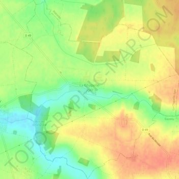
Name: La Chapelle-Iger topographic map, elevation, terrain.
Average elevation: 113 m
Minimum elevation: 88 m
Maximum elevation: 132 m

Click on the map to display elevation.
Name: La Chapelle-Iger topographic map, elevation, terrain.
Average elevation: 113 m
Minimum elevation: 88 m
Maximum elevation: 132 m