
Briançon topographic map
Interactive map
Click on the map to display elevation.
About this map
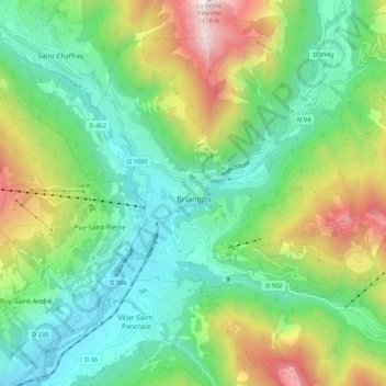
Name: Briançon topographic map, elevation, terrain.
Average elevation: 1,614 m
Minimum elevation: 1,160 m
Maximum elevation: 2,597 m
Due to its elevation, Briançon features a warm-summer humid continental climate (Köppen. Dfb), under the Köppen system. Warm summers, but cold, snowy winters.
Other topographic maps
Click on a map to view its topography, its elevation and its terrain.
Le Dévoluy
France > Provence-Alpes-Côte d'Azur > Hautes-Alpes > Le Dévoluy
Le Dévoluy, Gap, Hautes-Alpes, Provence-Alpes-Côte d'Azur, Metropolitan France, 05250, France
Average elevation: 1,642 m