
Esteribar topographic map
Interactive map
Click on the map to display elevation.
About this map
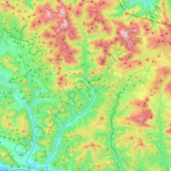
Name: Esteribar topographic map, elevation, terrain.
Location: Esteribar, Iruñerria / Comarca de Pamplona, Espagne (42.83489 -1.59761 43.06432 -1.46888)
Average elevation: 784 m
Minimum elevation: 428 m
Maximum elevation: 1,443 m
Other topographic maps
Click on a map to view its topography, its elevation and its terrain.
Zubiri
Espagne > Iruñerria / Comarca de Pamplona > Esteribar
Zubiri, Esteribar, Iruñerria / Comarca de Pamplona, 31630, Espagne
Average elevation: 642 m