
Montauban topographic map
Interactive map
Click on the map to display elevation.
About this map
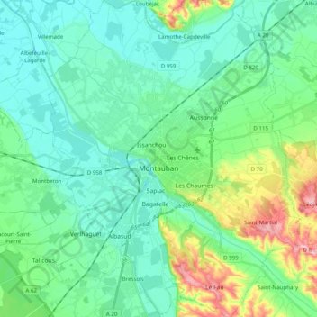
Name: Montauban topographic map, elevation, terrain.
Average elevation: 104 m
Minimum elevation: 71 m
Maximum elevation: 215 m
Other topographic maps
Click on a map to view its topography, its elevation and its terrain.
Le Causé
France > Occitania > Tarn-et-Garonne
Le Causé, Castelsarrasin, Tarn-et-Garonne, Occitania, Metropolitan France, 82500, France
Average elevation: 186 m
Valence d'Agen
France > Occitania > Tarn-et-Garonne > Valence
Valence d'Agen, Valence, Castelsarrasin, Tarn-et-Garonne, Occitania, Metropolitan France, 82400, France
Average elevation: 65 m