
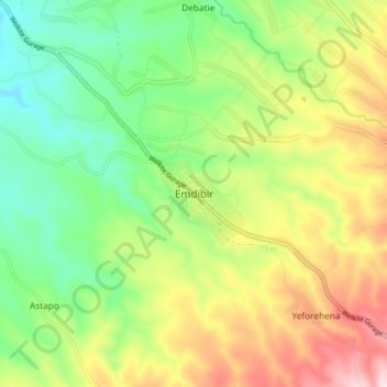
Emdibir topographic map
Interactive map
Click on the map to display elevation.
About this map
Name: Emdibir topographic map, elevation, terrain.
Average elevation: 2,084 m
Minimum elevation: 1,937 m
Maximum elevation: 2,303 m
Emdibir is a town south-west of Addis Ababa, in the central part of Ethiopia. Located in the Gurage Zone of the Southern Nations, Nationalities and Peoples' Region, this town has a latitude and longitude of 8°7′N 37°56′E / 8.117°N 37.933°E / 8.117; 37.933 and an elevation between 2130 and 2164 meters above sea level. It is the administrative center of Cheha woreda.
Other topographic maps
Click on a map to view its topography, its elevation and its terrain.
Butajira
Ethiopia > Southern Nations, Nationalities, and Peoples
Butajira, Guraghe, Southern Nations, Nationalities, and Peoples, Ethiopia
Average elevation: 2,078 m
Hayqoch And Butajira
Ethiopia > Southern Nations, Nationalities, and Peoples
Hayqoch And Butajira, Selti, Southern Nations, Nationalities, and Peoples, Ethiopia
Average elevation: 1,842 m