
Brookings County topographic map
Interactive map
Click on the map to display elevation.
About this map
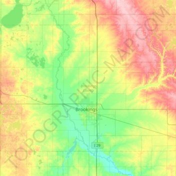
Name: Brookings County topographic map, elevation, terrain.
Location: Brookings County, South Dakota, United States (44.19593 -97.12974 44.54378 -96.45182)
Average elevation: 525 m
Minimum elevation: 472 m
Maximum elevation: 617 m
Brookings County is on the east side of South Dakota. Its east boundary line abuts the west boundary line of the state of Minnesota. The Big Sioux River flows south-southeastward through the east central part of the county; its point of entry into Moody County marks Brookings County's lowest elevation: 1,568' (478m) ASL.
Other topographic maps
Click on a map to view its topography, its elevation and its terrain.
Brookings
United States > South Dakota > Brookings County
Brookings, Brookings County, South Dakota, United States
Average elevation: 495 m