
Wealden topographic map
Interactive map
Click on the map to display elevation.
About this map
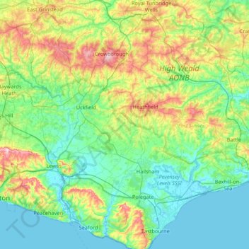
Name: Wealden topographic map, elevation, terrain.
Location: Wealden, East Sussex, South East, England, United Kingdom (50.73687 -0.03624 51.14746 0.45013)
Average elevation: 61 m
Minimum elevation: -2 m
Maximum elevation: 247 m
Other topographic maps
Click on a map to view its topography, its elevation and its terrain.
Fletching
United Kingdom > England > Wealden
Fletching, Wealden, East Sussex, South East, England, United Kingdom
Average elevation: 47 m