
Petit Ventron topographic map
Interactive map
Click on the map to display elevation.
About this map
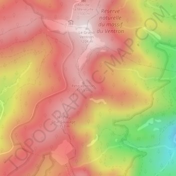
Name: Petit Ventron topographic map, elevation, terrain.
Average elevation: 974 m
Minimum elevation: 559 m
Maximum elevation: 1,202 m
Other topographic maps
Click on a map to view its topography, its elevation and its terrain.
Jungfrauenkopf
France > Grand Est > Fellering
Jungfrauenkopf, Fellering, Thann-Guebwiller, Haut-Rhin, Grand Est, France métropolitaine, 68470, France
Average elevation: 1,075 m