
Książ topographic map
Interactive map
Click on the map to display elevation.
About this map
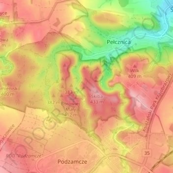
Name: Książ topographic map, elevation, terrain.
Location: Książ, Wałbrzych, Lower Silesian Voivodeship, Poland (50.82888 16.24944 50.85414 16.31306)
Average elevation: 376 m
Minimum elevation: 284 m
Maximum elevation: 432 m
Other topographic maps
Click on a map to view its topography, its elevation and its terrain.
Zamek Książ
Poland > Lower Silesian Voivodeship > Wałbrzych
Zamek Książ, Piastów Śląskich, Książ, Wałbrzych, Lower Silesian Voivodeship, 58-306, Poland
Average elevation: 372 m