
City of Ogdensburg topographic map
Interactive map
Click on the map to display elevation.
About this map
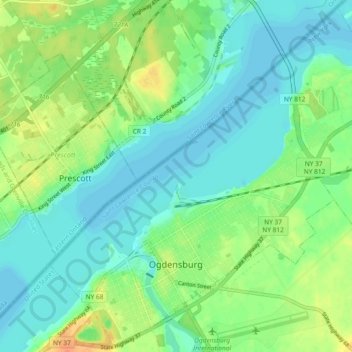
Name: City of Ogdensburg topographic map, elevation, terrain.
Average elevation: 85 m
Minimum elevation: 72 m
Maximum elevation: 111 m
Other topographic maps
Click on a map to view its topography, its elevation and its terrain.
Village of Potsdam
United States > New York > Saint Lawrence County > Town of Potsdam
Village of Potsdam, Town of Potsdam, Saint Lawrence County, New York, 13699, United States
Average elevation: 133 m
Village of Waddington
United States > New York > Saint Lawrence County
Village of Waddington, Town of Waddington, Saint Lawrence County, New York, 13694, United States
Average elevation: 80 m
Matilda Bay
United States > New York > Saint Lawrence County
Matilda Bay, Town of Clifton, Saint Lawrence County, New York, 12927, United States
Average elevation: 467 m
Palmerville
United States > New York > Saint Lawrence County > Town of Russell
Palmerville, Town of Russell, Saint Lawrence County, New York, 13684, United States
Average elevation: 233 m