
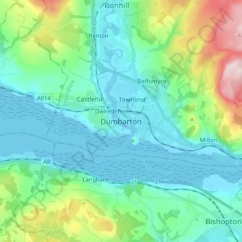
Dumbarton topographic map
Interactive map
Click on the map to display elevation.
About this map
Name: Dumbarton topographic map, elevation, terrain.
Average elevation: 75 m
Minimum elevation: -3 m
Maximum elevation: 343 m
Other topographic maps
Click on a map to view its topography, its elevation and its terrain.
Faifley
United Kingdom > Scotland > West Dunbartonshire
Faifley, West Dunbartonshire, Scotland, G81 5EB, United Kingdom
Average elevation: 112 m
Alexandria
United Kingdom > Scotland > West Dunbartonshire
Alexandria, West Dunbartonshire, Scotland, G83 0PB, United Kingdom
Average elevation: 95 m
Clydebank
United Kingdom > Scotland > West Dunbartonshire
Clydebank, West Dunbartonshire, Scotland, G81 2UA, United Kingdom
Average elevation: 44 m
Cochno Hill
United Kingdom > Scotland > West Dunbartonshire
Cochno Hill, West Dunbartonshire, Scotland, G81 6RW, United Kingdom
Average elevation: 269 m
Bonhill
United Kingdom > Scotland > West Dunbartonshire
Bonhill, West Dunbartonshire, Scotland, G83 9HS, United Kingdom
Average elevation: 101 m
Cochno
United Kingdom > Scotland > West Dunbartonshire > Faifley > Cochno
Cochno, Faifley, West Dunbartonshire, Scotland, G81 5QJ, United Kingdom
Average elevation: 178 m
Gartocharn
United Kingdom > Scotland > West Dunbartonshire
Gartocharn, West Dunbartonshire, Scotland, G83 8RX, United Kingdom
Average elevation: 54 m
Bowling
United Kingdom > Scotland > West Dunbartonshire
Bowling, West Dunbartonshire, Scotland, G60 5AH, United Kingdom
Average elevation: 105 m
Tullichewan Muir
United Kingdom > Scotland > West Dunbartonshire > Alexandria > Upper Stoneymollan
Tullichewan Muir, Upper Stoneymollan, Alexandria, West Dunbartonshire, Scotland, G83 8QU, United Kingdom
Average elevation: 169 m