
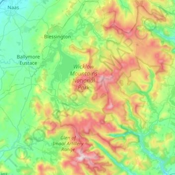
Wicklow Mountains National Park topographic map
Interactive map
Click on the map to display elevation.
About this map
Name: Wicklow Mountains National Park topographic map, elevation, terrain.
Average elevation: 324 m
Minimum elevation: 78 m
Maximum elevation: 919 m
Other topographic maps
Click on a map to view its topography, its elevation and its terrain.
Newfarm
Newfarm, The Rower, The Municipal District of Callan — Thomastown, County Kilkenny, Leinster, Ireland
Average elevation: 33 m
Blanchardstown
Blanchardstown, Fingal, County Dublin, Leinster, D15 KPW7, Ireland
Average elevation: 61 m
Rathmines
Ireland > County Dublin > Dublin
Rathmines, Rathmines West B Ward 1986, Dublin, County Dublin, Leinster, Ireland
Average elevation: 28 m
Louisburgh
Louisburgh, Westport-Belmullet Municipal District, County Mayo, Connacht, Ireland
Average elevation: 17 m
Ballina
Ballina, Ballina Municipal District, County Mayo, Connacht, Ireland
Average elevation: 19 m
Gunpoint
Gunpoint, Lowertown, West Cork, County Cork, Munster, Ireland
Average elevation: 14 m
Killarney
Killarney, Killarney Municipal District, County Kerry, Munster, Ireland
Average elevation: 57 m
Newbridge
Newbridge, The Municipal District of Kildare — Newbridge, County Kildare, Leinster, Ireland
Average elevation: 95 m
Ballyboden
Ballyboden, South Dublin, County Dublin, Leinster, D14 VY33, Ireland
Average elevation: 83 m
Took
Took, Modelligo, The Municipal District of Dungarvan — Lismore, County Waterford, Munster, Ireland
Average elevation: 169 m
Dún Laoghaire
Dún Laoghaire, Dún Laoghaire-Rathdown, County Dublin, Leinster, A96 T860, Ireland
Average elevation: 21 m
Powderly Lower
Ireland > County Donegal > Kildoney
Powderly Lower, Kildoney, Castlefinn ED, Lifford-Stranorlar Municipal District, County Donegal, Ulster, Ireland
Average elevation: 57 m
Thomastown
Thomastown, The Municipal District of Callan — Thomastown, County Kilkenny, Leinster, Ireland
Average elevation: 44 m
Waterfall
Waterfall, Inishkenny, Municipal District of Carrigaline, County Cork, Munster, T12 CYF2, Ireland
Average elevation: 96 m
Moyle Beg
Moyle Beg, Cormeen ED, Ballybay-Clones Municipal District, County Monaghan, Ulster, Ireland
Average elevation: 135 m
Carlingford
Carlingford, County Louth, Leinster, Ireland
Average elevation: 84 m
Saint Kevins Ward 1986
Ireland > County Dublin > Dublin
Saint Kevins Ward 1986, Dublin, County Dublin, Leinster, Ireland
Average elevation: 18 m
Letterkenny
Letterkenny, County Donegal, Ulster, Ireland
Average elevation: 92 m
Camira Glebe
Camira Glebe, Rosenallis ED, The Municipal District of Borris-in-Ossory — Mountmellick, County Laois, Leinster, Ireland
Average elevation: 82 m
Naas
Naas, The Municipal District of Naas, County Kildare, Leinster, Ireland
Average elevation: 99 m
Kilcullen
Kilcullen, Municipal District of Macroom, County Cork, Munster, Ireland
Average elevation: 216 m
Dunmore
Dunmore, Tuam Municipal District, County Galway, Connacht, Ireland
Average elevation: 63 m
Jerpoint Church
Jerpoint Church, The Municipal District of Callan — Thomastown, County Kilkenny, Leinster, Ireland
Average elevation: 94 m
Clara
Clara, Clara ED, The Municipal District of Tullamore, County Offaly, Leinster, Ireland
Average elevation: 62 m
Listowel Municipal District
Listowel Municipal District, County Kerry, Munster, Ireland
Average elevation: 67 m
Cliffs of Moher
Cliffs of Moher, Ballysteen ED, West Clare Municipal District, County Clare, Munster, Ireland
Average elevation: 55 m
The Glen
Ireland > County Cork > Cork
The Glen, Dublin Hill, The Glen B, Cork, County Cork, Munster, T23 D437, Ireland
Average elevation: 57 m
Holycross
Holycross, The Municipal District of Thurles, County Tipperary, Munster, Ireland
Average elevation: 99 m
The Municipal District of Greystones
The Municipal District of Greystones, County Wicklow, Leinster, Ireland
Average elevation: 89 m
The Municipal District of Bray
The Municipal District of Bray, County Wicklow, Leinster, Ireland
Average elevation: 283 m
Athenry-Oranmore Municipal District
Athenry-Oranmore Municipal District, County Galway, Connacht, Ireland
Average elevation: 42 m
Killaloe Municipal District
Killaloe Municipal District, County Clare, Munster, Ireland
Average elevation: 85 m
Wexford
Wexford, The Borough District of Wexford, County Wexford, Leinster, Ireland
Average elevation: 23 m
Dingle
Dingle, Kenmare Municipal District, County Kerry, Munster, Ireland
Average elevation: 121 m
Connolly
Connolly, Kinturk ED, West Clare Municipal District, County Clare, Munster, Ireland
Average elevation: 96 m
Glenbrook
Ireland > County Cork > Municipal District of Carrigaline
Glenbrook, Municipal District of Carrigaline, County Cork, Munster, T12 KT5N, Ireland
Average elevation: 50 m
Mother Mountain
Mother Mountain, The Municipal District of Nenagh, County Tipperary, Munster, Ireland
Average elevation: 368 m
Ballymacarbry
Ballymacarbry, The Municipal District of Comeragh, County Waterford, Munster, Ireland
Average elevation: 145 m
Kilkenny
Kilkenny, County Kilkenny, Leinster, Ireland
Average elevation: 62 m
Ruan
Ruan, West Clare Municipal District, County Clare, Munster, Ireland
Average elevation: 22 m
Collinstown
Collinstown, Airport ED, Fingal, County Dublin, Leinster, Ireland
Average elevation: 62 m