
Lake Manyara topographic map
Interactive map
Click on the map to display elevation.
About this map
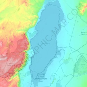
Name: Lake Manyara topographic map, elevation, terrain.
Location: Lake Manyara, Babati, Manyara, Northern Zone, Tanzania (-3.84467 35.73179 -3.40006 35.91277)
Average elevation: 1,174 m
Minimum elevation: 951 m
Maximum elevation: 2,043 m
Other topographic maps
Click on a map to view its topography, its elevation and its terrain.
Tarangire National Park
Tarangire National Park, Ridge Road, Babati, Manyara, Northern Zone, Tanzania
Average elevation: 1,252 m