
Harrisville topographic map
Interactive map
Click on the map to display elevation.
About this map
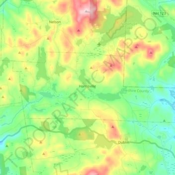
Name: Harrisville topographic map, elevation, terrain.
Average elevation: 422 m
Minimum elevation: 284 m
Maximum elevation: 673 m
Other topographic maps
Click on a map to view its topography, its elevation and its terrain.
Keene
United States > New Hampshire > Cheshire County
Keene, Cheshire County, New Hampshire, United States
Average elevation: 263 m
Rindge
United States > New Hampshire > Cheshire County
Rindge, Cheshire County, New Hampshire, United States
Average elevation: 343 m
North Swanzey
United States > New Hampshire > Cheshire County > Keene > North Swanzey
North Swanzey, Keene, Cheshire County, New Hampshire, 03435, United States
Average elevation: 169 m
Jaffrey
United States > New Hampshire > Cheshire County
Jaffrey, Cheshire County, New Hampshire, 03452, United States
Average elevation: 351 m