
Dyaul Island topographic map
Interactive map
Click on the map to display elevation.
About this map
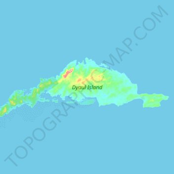
Name: Dyaul Island topographic map, elevation, terrain.
Average elevation: 3 m
Minimum elevation: -1 m
Maximum elevation: 173 m
Other topographic maps
Click on a map to view its topography, its elevation and its terrain.
Lihir Island
Papua New Guinea > New Ireland
Lihir Island, New Ireland, Islands Region, Papua New Guinea
Average elevation: 71 m
New Hanover Island
Papua New Guinea > New Ireland
New Hanover Island, Lamet District, New Ireland, Islands Region, Papua New Guinea
Average elevation: 55 m
Mussau Island
Papua New Guinea > New Ireland
Mussau Island, New Ireland, Islands Region, Papua New Guinea
Average elevation: 70 m
Pana Island
Papua New Guinea > New Ireland
Pana Island, Kavieng District, New Ireland, Islands Region, Papua New Guinea
Average elevation: 118 m
Tench Island
Papua New Guinea > New Ireland
Tench Island, Lamet District, New Ireland, Islands Region, Papua New Guinea
Average elevation: 1 m
Latangai Island
Papua New Guinea > New Ireland
Latangai Island, Kavieng District, New Ireland, Islands Region, Papua New Guinea
Average elevation: 23 m