
Yasawa Island topographic map
Interactive map
Click on the map to display elevation.
About this map
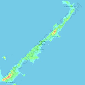
Name: Yasawa Island topographic map, elevation, terrain.
Location: Yasawa Island, Western, Fiji (-16.84627 177.43593 -16.69359 177.59247)
Average elevation: 3 m
Minimum elevation: 0 m
Maximum elevation: 165 m
Other topographic maps
Click on a map to view its topography, its elevation and its terrain.