
Hollow Mountain topographic map
Interactive map
Click on the map to display elevation.
About this map
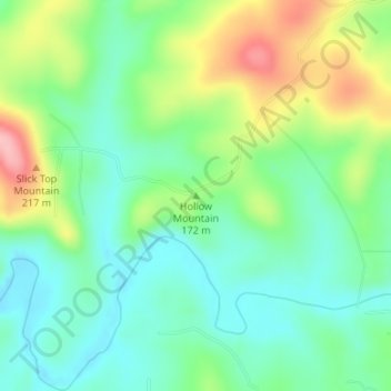
Name: Hollow Mountain topographic map, elevation, terrain.
Location: Hollow Mountain, Izard County, Arkansas, USA (36.07280 -92.02326 36.07290 -92.02316)
Average elevation: 159 m
Minimum elevation: 110 m
Maximum elevation: 254 m
Other topographic maps
Click on a map to view its topography, its elevation and its terrain.
Ozark Plateau
Ozark Plateau, Coburn Loop, Clark County, Arkansas, USA
Average elevation: 51 m
New Blaine
USA > Arkansas > New Blaine
New Blaine, Logan County, Arkansas, 72851, USA
Average elevation: 132 m