
Bukit Timah Hill topographic map
Interactive map
Click on the map to display elevation.
About this map
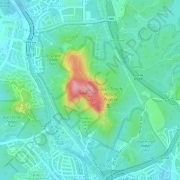
Name: Bukit Timah Hill topographic map, elevation, terrain.
Location: Bukit Timah Hill, Northwest, 588192, Singapore (1.35464 103.77632 1.35474 103.77642)
Average elevation: 52 m
Minimum elevation: 14 m
Maximum elevation: 168 m
Other topographic maps
Click on a map to view its topography, its elevation and its terrain.
Dhoby Ghaut Green
Singapore > Central > Singapore
Dhoby Ghaut Green, Museum, Singapore, Central, 238826, Singapore
Average elevation: 19 m
Rain Forest
Singapore > Central > Singapore
Rain Forest, Tanglin, Singapore, Central, 259569, Singapore
Average elevation: 22 m
Singapore Botanic Gardens
Singapore > Central > Singapore
Singapore Botanic Gardens, Tanglin, Singapore, Central, 259569, Singapore
Average elevation: 22 m
Alexandra Canal
Alexandra Canal, Singapore, Central, 149309, Singapore
Average elevation: 21 m
Floating Platform @ Bishan Park Pond Gardens
Floating Platform @ Bishan Park Pond Gardens, Singapore, Central, Singapore
Average elevation: 24 m