
Mount Misery topographic map
Interactive map
Click on the map to display elevation.
About this map
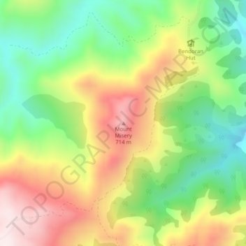
Name: Mount Misery topographic map, elevation, terrain.
Location: Mount Misery, Dunedin, Dunedin City, Otago, New Zealand (-45.67502 170.44507 -45.67492 170.44517)
Average elevation: 455 m
Minimum elevation: 211 m
Maximum elevation: 754 m
Other topographic maps
Click on a map to view its topography, its elevation and its terrain.
Saint Kilda Beach
Saint Kilda Beach, St. Clair to Lawyers Head Trail, Saint Clair, Dunedin, Dunedin City, Otago, 9001, New Zealand
Average elevation: 4 m
Mount Charles
Mount Charles, Dunedin, Dunedin City, Otago, New Zealand
Average elevation: 117 m
Mount Cargill
Mount Cargill, Dunedin, Dunedin City, Otago, New Zealand
Average elevation: 424 m