
Sylhet District topographic map
Interactive map
Click on the map to display elevation.
About this map
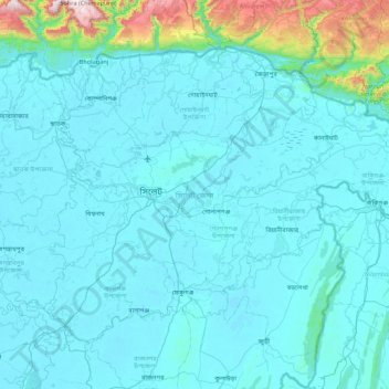
Name: Sylhet District topographic map, elevation, terrain.
Location: Sylhet District, Sylhet Division, Bangladesh (24.59260 91.63821 25.18833 92.49944)
Average elevation: 105 m
Minimum elevation: 3 m
Maximum elevation: 1,420 m
Other topographic maps
Click on a map to view its topography, its elevation and its terrain.
N'Mouja
Bangladesh > Sylhet Division > N'Mouja
N'Mouja, Moulvibazar District, Sylhet Division, Bangladesh
Average elevation: 27 m
Nabiganj
Bangladesh > Sylhet Division > Nabiganj
Nabiganj, Habiganj District, Sylhet Division, 3370, Bangladesh
Average elevation: 9 m