
Mallanganee topographic map
Interactive map
Click on the map to display elevation.
About this map
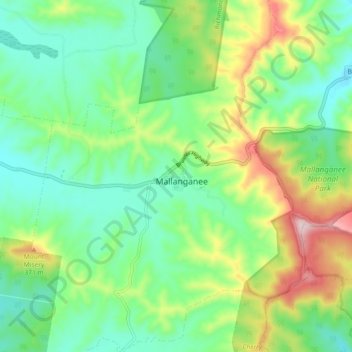
Name: Mallanganee topographic map, elevation, terrain.
Average elevation: 235 m
Minimum elevation: 134 m
Maximum elevation: 452 m
Other topographic maps
Click on a map to view its topography, its elevation and its terrain.
Mallanganee
Australia > New South Wales > Mallanganee
Mallanganee, Kyogle Council, New South Wales, 2469, Australia
Average elevation: 221 m
Mallanganee National Park
Australia > New South Wales > Mallanganee
Mallanganee National Park, Pennefathers Road, Mallanganee, Kyogle Council, New South Wales, 2469, Australia
Average elevation: 286 m