
Beavercreek topographic map
Interactive map
Click on the map to display elevation.
About this map
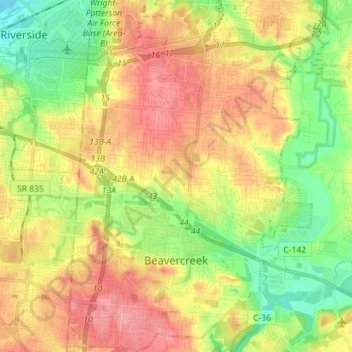
Name: Beavercreek topographic map, elevation, terrain.
Location: Beavercreek, Greene County, Ohio, United States (39.68086 -84.10662 39.79013 -84.00828)
Average elevation: 274 m
Minimum elevation: 230 m
Maximum elevation: 318 m
Other topographic maps
Click on a map to view its topography, its elevation and its terrain.
Bellbrook
United States > Ohio > Greene County
Bellbrook, Greene County, Ohio, 45305, United States
Average elevation: 262 m
Wrightview
United States > Ohio > Greene County > Fairborn
Wrightview, Fairborn, Greene County, Ohio, 45435, United States
Average elevation: 269 m
New Germany
United States > Ohio > Greene County > Beavercreek > New Germany
New Germany, Beavercreek, Greene County, Ohio, 45431, United States
Average elevation: 281 m
Wilberforce
United States > Ohio > Greene County > Wilberforce
Wilberforce, Xenia Township, Greene County, Ohio, 45384, United States
Average elevation: 297 m
Upper Valley Trailer Court
United States > Ohio > Greene County > Upper Valley Trailer Court
Upper Valley Trailer Court, Bath Township, Greene County, Ohio, 45433, United States
Average elevation: 257 m