
Simpelveld topographic map
Interactive map
Click on the map to display elevation.
About this map
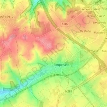
Name: Simpelveld topographic map, elevation, terrain.
Location: Simpelveld, Limburg, Nederland (50.81942 5.95325 50.86023 6.00540)
Average elevation: 172 m
Minimum elevation: 117 m
Maximum elevation: 217 m
Other topographic maps
Click on a map to view its topography, its elevation and its terrain.
Molsberg
Nederland > Limburg > Simpelveld
Molsberg, Simpelveld, Limburg, Nederland, 6369 GP, Nederland
Average elevation: 172 m
Bosschenhuizen
Nederland > Limburg > Simpelveld
Bosschenhuizen, Simpelveld, Limburg, Nederland, 6369 BK, Nederland
Average elevation: 171 m
Huls
Nederland > Limburg > Simpelveld
Huls, Simpelveld, Limburg, Nederland, 6369 ET, Nederland
Average elevation: 172 m
In de Gaas
Nederland > Limburg > Simpelveld > In de Gaas
In de Gaas, Simpelveld, Limburg, Nederland, 6369VA, Nederland
Average elevation: 172 m