
Denali National Park and Preserve topographic map
Interactive map
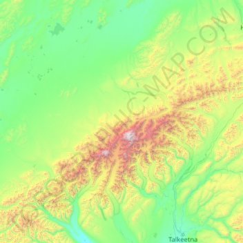
Click on the map to display elevation.
About this map
Name: Denali National Park and Preserve topographic map, elevation, terrain.
Average elevation: 777 m
Minimum elevation: 70 m
Maximum elevation: 6,139 m
Denali National Park and Preserve is an American national park and preserve located in Interior Alaska, centered on Denali, the highest mountain in North America. The park and contiguous preserve encompass 6,045,153 acres (9,446 sq mi; 24,464 km2) which is larger than the state of New Hampshire. On December 2, 1980, 2,146,580-acre (3,354 sq mi; 8,687 km2) Denali Wilderness was established within the park. Denali's landscape is a mix of forest at the lowest elevations, including deciduous taiga, with tundra at middle elevations, and glaciers, snow, and bare rock at the highest elevations. The longest glacier is the Kahiltna Glacier. Wintertime activities include dog sledding, cross-country skiing, and snowmobiling. The park received 594,660 recreational visitors in 2018.
Other topographic maps
Click on a map to view its topography, its elevation and its terrain.
Delta Road
United States of America > Alaska > King Cove
Delta Road, King Cove, Aleutians East, Alaska, United States of America
Average elevation: 119 m
Hinchinbrook Island
United States of America > Alaska
Hinchinbrook Island, Unorganized Borough, Alaska, United States of America
Average elevation: 68 m
Glacier Bay National Park
United States of America > Alaska
Glacier Bay National Park, Unorganized Borough, Alaska, United States of America
Average elevation: 572 m
Prudhoe Bay
United States of America > Alaska > Prudhoe Bay
Prudhoe Bay, North Slope, Alaska, 99734, United States of America
Average elevation: 10 m