
Village of Ossining topographic map
Interactive map
Click on the map to display elevation.
About this map
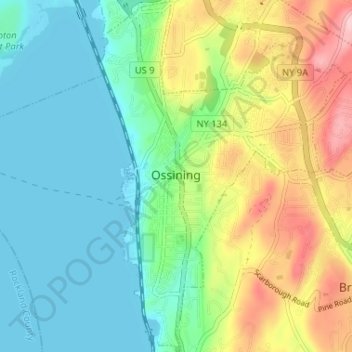
Name: Village of Ossining topographic map, elevation, terrain.
Average elevation: 61 m
Minimum elevation: -2 m
Maximum elevation: 189 m
Other topographic maps
Click on a map to view its topography, its elevation and its terrain.
Cecil Park
United States > New York > Westchester County > City of Yonkers
Cecil Park, City of Yonkers, Westchester County, New York, 10707, United States
Average elevation: 70 m
Chester Heights
United States > New York > Westchester County > City of New Rochelle
Chester Heights, City of New Rochelle, Westchester County, New York, 10801, United States
Average elevation: 36 m
City of White Plains
United States > New York > Westchester County
City of White Plains, Westchester County, New York, United States
Average elevation: 83 m
Village of Buchanan
United States > New York > Westchester County > Town of Cortlandt
Village of Buchanan, Town of Cortlandt, Westchester County, New York, 10511, United States
Average elevation: 28 m
Lincoln
United States > New York > Westchester County > City of Yonkers
Lincoln, City of Yonkers, Westchester County, New York, 10705, United States
Average elevation: 49 m
Village of Scarsdale
United States > New York > Westchester County
Village of Scarsdale, Westchester County, New York, 10583, United States
Average elevation: 76 m
Town of Mount Pleasant
United States > New York > Westchester County > Town of Mount Pleasant
Town of Mount Pleasant, Westchester County, New York, United States
Average elevation: 95 m
Yonkers
United States > New York > Westchester County > Yonkers
Yonkers, Westchester County, New York, United States
Average elevation: 58 m