
Bay County topographic map
Interactive map
Click on the map to display elevation.
About this map
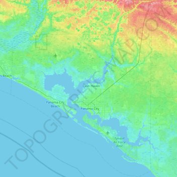
Name: Bay County topographic map, elevation, terrain.
Location: Bay County, Florida, United States (29.90103 -85.99989 30.56742 -85.38415)
Average elevation: 13 m
Minimum elevation: -4 m
Maximum elevation: 84 m
Other topographic maps
Click on a map to view its topography, its elevation and its terrain.
Panama City
United States > Florida > Bay County
Panama City, Bay County, Florida, United States
Average elevation: 6 m
Panama City Beach
United States > Florida > Bay County
Panama City Beach, Bay County, Florida, United States
Average elevation: 2 m