
Reschenpass topographic map
Interactive map
Click on the map to display elevation.
Reschenpass
Der Pass überquert den Alpenhauptkamm und trennt die Ötztaler Alpen im Osten von der Sesvennagruppe im Westen. Er verbindet den Vinschgau (Südtirol, Italien) mit dem Oberen Gericht (Tirol, Österreich) bzw. das Etschtal mit dem Oberinntal. Die Passhöhe selbst liegt vollständig auf italienischem Staatsgebiet und befindet sich auf einer Seehöhe von 1507 m unmittelbar nördlich des Dorfs Reschen bzw. des Reschensees. Die Grenze zwischen Italien und Österreich verläuft seit dem Inkrafttreten des Vertrags von Saint-Germain 1920 ca. zwei Kilometer nördlich der Passhöhe. Etwas nordwestlich über der Passhöhe befindet sich an den Hängen des Piz Lad zudem das durch einen Dreiländerstein markierte Dreiländereck zur Schweiz bzw. zum Kanton Graubünden.
About this map
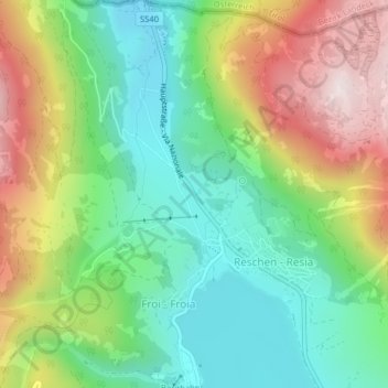
Name: Reschenpass topographic map, elevation, terrain.
Average elevation: 1,693 m
Minimum elevation: 1,454 m
Maximum elevation: 2,081 m
Other topographic maps
Click on a map to view its topography, its elevation and its terrain.
Reschensee
Italien > Trentino-Südtirol > Bozen > Graun > Froi
Im Reschensee wird das Wasser der Etsch, des Rojenbachs, des Karlinbachs und einiger kleinerer Zuflüsse gestaut. Der künstliche See hat mit sechs Kilometer Länge und an der breitesten Stelle etwa einem Kilometer Breite ein Stauvolumen von 120 Mio. m³, das fast vollständig als Speichervolumen genutzt wird…
Average elevation: 1,871 m