
Mahalangur Himal topographic map
Interactive map
Click on the map to display elevation.
About this map
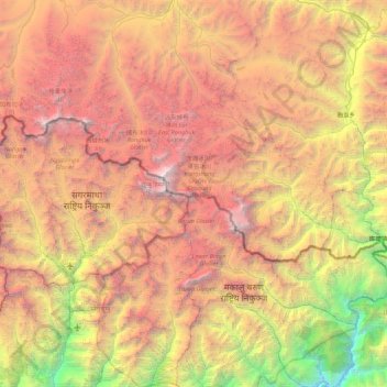
Name: Mahalangur Himal topographic map, elevation, terrain.
Location: Mahalangur Himal, Koshi Province, 56002, Nepal (27.56672 86.57967 28.34466 87.45194)
Average elevation: 4,724 m
Minimum elevation: 987 m
Maximum elevation: 8,792 m
Other topographic maps
Click on a map to view its topography, its elevation and its terrain.
Phaktanglung
Nepal > Koshi Province > Taplejung
Phaktanglung, Taplejung, Koshi Province, Nepal
Average elevation: 4,548 m
Mount Everest
Nepal > Koshi Province > Solukhumbu
Mount Everest, Khumbupasanglahmu, Solukhumbu, Koshi Province, Nepal
Average elevation: 7,850 m
Himalayas
Nepal > Koshi Province > Solukhumbu
Himalayas, Khumbupasanglahmu, Solukhumbu, Koshi Province, Nepal
Average elevation: 7,555 m