
Westrozebeke topographic map
Interactive map
Click on the map to display elevation.
About this map
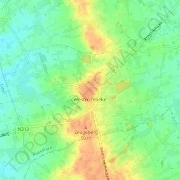
Name: Westrozebeke topographic map, elevation, terrain.
Location: Westrozebeke, Staden, Roeselare, West-Vlaanderen, België (50.91609 2.97290 50.95024 3.04078)
Average elevation: 31 m
Minimum elevation: 16 m
Maximum elevation: 51 m
Other topographic maps
Click on a map to view its topography, its elevation and its terrain.
Oostnieuwkerke
België > West-Vlaanderen > Roeselare > Staden
Oostnieuwkerke, Staden, Roeselare, West-Vlaanderen, 8840, België
Average elevation: 25 m