Geolocate

Halblech topographic map

Interactive map

Click on the map to display elevation.

About this map

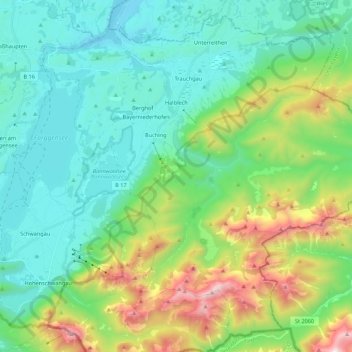
Name: Halblech topographic map, elevation, terrain.

Location: Halblech, Landkreis Ostallgäu, Bavaria, 87642, Germany (47.53362 10.73675 47.66767 10.95387)

Average elevation: 1,092 m

Minimum elevation: 736 m

Maximum elevation: 2,139 m

Other topographic maps

Click on a map to view its topography, its elevation and its terrain.

Hohenschwangau

Germany > Bavaria > Landkreis Ostallgäu

Average elevation: 1,002 m

Tegelberg

Germany > Bavaria > Landkreis Ostallgäu > Schwangau

Average elevation: 1,352 m

Hohenschwangau

Germany > Bavaria > Landkreis Ostallgäu

Average elevation: 995 m

Jaufen

Germany > Bavaria > Landkreis Ostallgäu > Halblech

Average elevation: 1,419 m

Algers

Germany > Bavaria > Landkreis Ostallgäu > Obergünzburg > Algers

Average elevation: 808 m