
Hobart topographic map
Interactive map
Click on the map to display elevation.
About this map
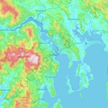
Name: Hobart topographic map, elevation, terrain.
Location: Hobart, City of Hobart, Tasmania, Australia (-43.10362 147.09169 -42.65538 147.64559)
Average elevation: 179 m
Minimum elevation: -2 m
Maximum elevation: 1,260 m
Although Hobart itself rarely receives snow during the winter due to the foehn effect created by the Central Highlands (the city's geographic position causes a rainshadow), the adjacent Kunanyi/Mount Wellington is frequently seen with a snowcap throughout the year including in summer. During the 20th century, the city itself has received snowfalls at sea level on average only once every 5 years; however, outer suburbs lying higher on the slopes of Mount Wellington receive snow more often, owing to the more exposed position coupled with them resting at higher altitude. These snow-bearing winds often carry on through Tasmania and Victoria to the Snowy Mountains in Victoria and southern New South Wales.
Other topographic maps
Click on a map to view its topography, its elevation and its terrain.
Cradle Mountain
Australia > Tasmania > Cradle Mountain
Cradle Mountain, Cradle Mount Summit Track, Cradle Mountain, Meander Valley, Tasmania, Australia
Average elevation: 1,144 m
Launceston
Australia > Tasmania > Launceston
Launceston, Tasmania, 7250, Australia
Average elevation: 218 m
Mount Lloyd
Mount Lloyd, Derwent Valley, Tasmania, 7140, Australia
Average elevation: 558 m
West Kentish
West Kentish, Kentish, Tasmania, 7306, Australia
Average elevation: 291 m
West Ulverstone
Australia > Tasmania > Ulverstone
West Ulverstone, Ulverstone, Central Coast, Tasmania, 7315, Australia
Average elevation: 26 m
Connellys Marsh
Connellys Marsh, Sorell, Tasmania, 7173, Australia
Average elevation: 41 m
Mount Direction
Mount Direction, Hobart, City of Clarence, Tasmania, 7017, Australia
Average elevation: 166 m
Styx River
Australia > Tasmania > Westerway
Styx River, Westerway, Derwent Valley, Tasmania, Australia
Average elevation: 548 m
West Montagu
West Montagu, Circular Head, Tasmania, 7330, Australia
Average elevation: 35 m
Bruny Island
Australia > Tasmania > Alonnah
Bruny Island, Alonnah, Kingborough, Tasmania, Australia
Average elevation: 59 m
Arthurs Lake
Arthurs Lake, Central Highlands, Tasmania, 7030, Australia
Average elevation: 910 m
Garden Island Creek
Garden Island Creek, Huon Valley, Tasmania, 7112, Australia
Average elevation: 153 m
Lower Turners Marsh
Lower Turners Marsh, City of Launceston, Tasmania, 7267, Australia
Average elevation: 141 m
Lower Longley
Lower Longley, Hobart, Kingborough, Tasmania, 7109, Australia
Average elevation: 338 m
Launceston
Launceston, City of Launceston, Tasmania, Australia
Average elevation: 194 m
Greens Beach
Greens Beach, West Tamar, Tasmania, 7270, Australia
Average elevation: 30 m
Launceston
Launceston, City of Launceston, Tasmania, 7250, Australia
Average elevation: 26 m
Claude Road
Claude Road, Kentish, Tasmania, 7306, Australia
Average elevation: 444 m
Black Hills
Black Hills, Derwent Valley, Tasmania, 7140, Australia
Average elevation: 432 m
Chain Of Lagoons
Chain Of Lagoons, Break O'Day, Tasmania, 7215, Australia
Average elevation: 154 m
Deddington
Deddington, Northern Midlands, Tasmania, 7212, Australia
Average elevation: 358 m
Selfs Point
Selfs Point, New Town, Hobart, City of Hobart, Tasmania, 7008, Australia
Average elevation: 17 m
Mount Wellington
Mount Wellington, City of Hobart, Tasmania, Australia
Average elevation: 941 m
Lake Murchison
Australia > Tasmania > Tullah > Lake St Clair
Lake Murchison, Lake St Clair, Tullah, West Coast, Tasmania, Australia
Average elevation: 531 m
Lower Barrington
Lower Barrington, Kentish, Tasmania, 7306, Australia
Average elevation: 202 m
Barrington
Barrington, Kentish, Tasmania, 7306, Australia
Average elevation: 228 m
Nowhere Else
Nowhere Else, Kentish, Tasmania, 7306, Australia
Average elevation: 279 m