
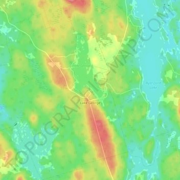
Lake George topographic map
Interactive map
Click on the map to display elevation.
About this map
Name: Lake George topographic map, elevation, terrain.
Average elevation: 227 m
Minimum elevation: 199 m
Maximum elevation: 276 m
Other topographic maps
Click on a map to view its topography, its elevation and its terrain.
Blue Mountain
Canada > Nova Scotia > Municipality of the County of Kings
Blue Mountain, Municipality of the County of Kings, Kings County, Nova Scotia, B4N 3V8, Canada
Average elevation: 224 m
Dalhousie Road
Canada > Nova Scotia > Municipality of the County of Kings
Dalhousie Road, East Dalhousie, Municipality of the County of Kings, Kings County, Nova Scotia, B0R 1H0, Canada
Average elevation: 207 m
Kingston
Canada > Nova Scotia > Municipality of the County of Kings
Kingston, Municipality of the County of Kings, Kings County, Nova Scotia, B0P 1R0, Canada
Average elevation: 30 m
Mountain Front
Canada > Nova Scotia > Municipality of the County of Kings
Mountain Front, Municipality of the County of Kings, Kings County, Nova Scotia, Canada
Average elevation: 166 m
Ogilvie
Canada > Nova Scotia > Municipality of the County of Kings
Ogilvie, Municipality of the County of Kings, Kings County, Nova Scotia, B0P 1E0, Canada
Average elevation: 41 m
Ross Creek
Canada > Nova Scotia > Municipality of the County of Kings
Ross Creek, Municipality of the County of Kings, Kings County, Nova Scotia, B0P 1H0, Canada
Average elevation: 100 m