
Sinai Peninsula topographic map
Interactive map
Click on the map to display elevation.
About this map
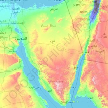
Name: Sinai Peninsula topographic map, elevation, terrain.
Location: Sinai Peninsula, Egypt (27.72414 32.31018 31.32347 34.90369)
Average elevation: 457 m
Minimum elevation: -415 m
Maximum elevation: 2,521 m
Sinai is one of the coldest provinces in Egypt because of its high altitudes and mountainous topographies. Winter temperatures in some of Sinai's cities and towns reach −16 °C (3 °F).
Other topographic maps
Click on a map to view its topography, its elevation and its terrain.
Mudiriyat al Gharbiyah
Mudiriyat al Gharbiyah, Seberbay, مديرية الغربية, Western, 31733, Egypt
Average elevation: 46 m
Tizmant East Village
Tizmant East Village, Bani Sweif, 62725, Egypt
Average elevation: 30 m
Districts of El Tagamoa El Khames
Egypt > Cairo > New Cairo City
Districts of El Tagamoa El Khames, New Cairo City, Cairo, 11936, Egypt
Average elevation: 278 m
Manshiyat al Sawamah
Manshiyat al Sawamah, Eastern, 44768, Egypt
Average elevation: 6 m
Industrial District
Egypt > Cairo > New Cairo City
Industrial District, New Cairo City, Cairo, 11835, Egypt
Average elevation: 350 m
Suez Canal
Egypt > Ismailia Governorate > Al Ismailiya
Suez Canal, Al Ismailiya, Ismailia Governorate, Egypt
Average elevation: 6 m
Toshka Lakes
Egypt > New Valley Governorate
Toshka Lakes, New Valley Governorate, Egypt
Average elevation: 154 m
Sohag
Egypt > Sohag Governorate > Sohag
Sohag, Markaz Tahta, Sohag Governorate, 82511, Egypt
Average elevation: 141 m
Jazirat adh Dhahab
Egypt > Giza Governorate > Jazirat adh Dhahab
Jazirat adh Dhahab, Giza Governorate, 12557, Egypt
Average elevation: 22 m
Sharm El Sheikh
Sharm El Sheikh, Ras Umm Sid, South Sinai, 46619, Egypt
Average elevation: 135 m
Ibrahimiya
Egypt > Alexandria Governorate > Ibrahimiya
Ibrahimiya, Alexandria Governorate, 21522, Egypt
Average elevation: 7 m
Kharga Oasis
Egypt > New Valley Governorate > Kharga Oasis
Kharga Oasis, New Valley Governorate, Egypt
Average elevation: 95 m
Remaya Square
Egypt > Giza Governorate > Remaya Square
Remaya Square, Giza Governorate, 12561, Egypt
Average elevation: 37 m
Al Haram
Egypt > Beni Suef Governorate > Al Haram
Al Haram, Beni Suef Governorate, Egypt
Average elevation: 28 m
Al Shaykh Fadl
Egypt > Minya Governate > Al Shaykh Fadl
Al Shaykh Fadl, Markaz Samalut, Minya Governate, Egypt
Average elevation: 35 m
Saint Catherine
Saint Catherine, Shibh Jazirat Sina', Egypt
Average elevation: 1,472 m
Elephantine Island
Egypt > Aswan Governorate > Aswan
Elephantine Island, Aswan, Aswan Governorate, Egypt
Average elevation: 106 m