
Pongakawa topographic map
Interactive map
Click on the map to display elevation.
About this map
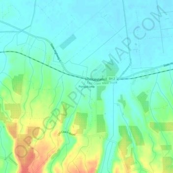
Name: Pongakawa topographic map, elevation, terrain.
Average elevation: 18 m
Minimum elevation: 2 m
Maximum elevation: 56 m
Other topographic maps
Click on a map to view its topography, its elevation and its terrain.
Katikati
New Zealand > Bay of Plenty > Western Bay of Plenty District
Katikati, Western Bay of Plenty District, Bay of Plenty, 3129, New Zealand
Average elevation: 52 m
Te Puke
New Zealand > Bay of Plenty > Western Bay of Plenty District
Te Puke, Western Bay of Plenty District, Bay of Plenty, 3182, New Zealand
Average elevation: 36 m