
Bay of Islands topographic map
Interactive map
Click on the map to display elevation.
About this map
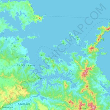
Name: Bay of Islands topographic map, elevation, terrain.
Location: Bay of Islands, Far North District, Northland, New Zealand (-35.37284 173.96268 -35.13719 174.30552)
Average elevation: 39 m
Minimum elevation: -1 m
Maximum elevation: 416 m
Other topographic maps
Click on a map to view its topography, its elevation and its terrain.
Tōtara North
New Zealand > Northland > Far North District > Bay of Islands-Whangaroa Community
Tōtara North, Bay of Islands-Whangaroa Community, Far North District, Northland, 0479, New Zealand
Average elevation: 67 m
Taipa
New Zealand > Northland > Far North District > Te Hiku Community
Taipa, Te Hiku Community, Far North District, Northland, New Zealand
Average elevation: 17 m
Bay of Islands-Whangaroa Community
New Zealand > Northland > Far North District
Bay of Islands-Whangaroa Community, Far North District, Northland, New Zealand
Average elevation: 91 m
Waiharara
New Zealand > Northland > Far North District > Te Hiku Community
Waiharara, Te Hiku Community, Far North District, Northland, New Zealand
Average elevation: 29 m
Te Hiku Community
New Zealand > Northland > Far North District
Te Hiku Community, Far North District, Northland, New Zealand
Average elevation: 29 m
Kaitaia
New Zealand > Northland > Far North District > Te Hiku Community
Kaitaia, Te Hiku Community, Far North District, Northland, 0441, New Zealand
Average elevation: 32 m
Cable Bay
New Zealand > Northland > Far North District > Te Hiku Community
Cable Bay, Te Hiku Community, Far North District, Northland, 0420, New Zealand
Average elevation: 17 m