
Tamatea / Dusky Sound topographic map
Interactive map
Click on the map to display elevation.
About this map
Name: Tamatea / Dusky Sound topographic map, elevation, terrain.
Average elevation: 378 m
Minimum elevation: -2 m
Maximum elevation: 1,416 m
Other topographic maps
Click on a map to view its topography, its elevation and its terrain.
Forest Range
New Zealand > Southland > Southland District > Waihopai Toetoe Community
Forest Range, Waihopai Toetoe Community, Southland District, Southland, New Zealand
Average elevation: 373 m
Nokomai River
New Zealand > Southland > Southland District
Nokomai River, Southland District, Southland, New Zealand
Average elevation: 390 m
Milford Sound
New Zealand > Southland > Southland District > Fiordland Community
Milford Sound, Fiordland Community, Southland District, Southland, New Zealand
Average elevation: 655 m
Rakahouka
New Zealand > Southland > Southland District > Waihopai Toetoe Community
Rakahouka, Waihopai Toetoe Community, Southland District, Southland, New Zealand
Average elevation: 38 m
Mount Elliot
New Zealand > Southland > Southland District > Fiordland Community
Mount Elliot, Fiordland Community, Southland District, Southland, New Zealand
Average elevation: 1,110 m
Hollyford River
New Zealand > Southland > Southland District > Fiordland Community
Hollyford River, Fiordland Community, Southland District, Southland, New Zealand
Average elevation: 14 m
Lake Alabaster
New Zealand > Southland > Southland District > Fiordland Community
Lake Alabaster, Fiordland Community, Southland District, Southland, New Zealand
Average elevation: 605 m
Manapouri
New Zealand > Southland > Southland District > Fiordland Community
Manapouri, Fiordland Community, Southland District, Southland, 7969, New Zealand
Average elevation: 213 m
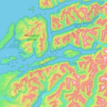
Resolution Island
New Zealand > Southland > Southland District
Resolution Island, Southland District, Southland, New Zealand
Average elevation: 197 m
Tuatapere Te Waewae Community
New Zealand > Southland > Southland District
Tuatapere Te Waewae Community, Southland District, Southland, 9620, New Zealand
Average elevation: 324 m
Garston
New Zealand > Southland > Southland District > Northern Community > Garston
Garston, Northern Community, Southland District, Southland, 9793, New Zealand
Average elevation: 373 m
Milford Sound
New Zealand > Southland > Southland District > Fiordland Community > Milford Sound
Milford Sound, Fiordland Community, Southland District, Southland, New Zealand
Average elevation: 304 m
Pigeon House
New Zealand > Southland > Southland District > Stewart Island / Rakiura Community
Pigeon House, Stewart Island / Rakiura Community, Southland District, Southland, New Zealand
Average elevation: 21 m
Puhipuhi takiwai / Mount Pembroke
New Zealand > Southland > Southland District > Fiordland Community
Puhipuhi takiwai / Mount Pembroke, Fiordland Community, Southland District, Southland, New Zealand
Average elevation: 1,262 m