
Meckesheim topographic map
Interactive map
Click on the map to display elevation.
About this map
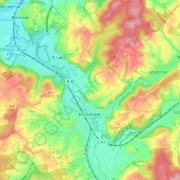
Name: Meckesheim topographic map, elevation, terrain.
Average elevation: 183 m
Minimum elevation: 123 m
Maximum elevation: 259 m
Other topographic maps
Click on a map to view its topography, its elevation and its terrain.
Sinsheim
Allemagne > Bade-Wurtemberg > Rhein-Neckar-Kreis
Sinsheim, Verwaltungsgemeinschaft Sinsheim, Rhein-Neckar-Kreis, Bade-Wurtemberg, 74889, Allemagne
Average elevation: 219 m
Malsch
Allemagne > Bade-Wurtemberg > Rhein-Neckar-Kreis
Malsch, Verwaltungsverband Rauenberg, Rhein-Neckar-Kreis, Bade-Wurtemberg, 69254, Allemagne
Average elevation: 153 m
Hockenheim
Allemagne > Bade-Wurtemberg > Rhein-Neckar-Kreis
Hockenheim, Verwaltungsgemeinschaft Hockenheim, Rhein-Neckar-Kreis, Bade-Wurtemberg, 68766, Allemagne
Average elevation: 101 m