
Birmingham topographic map
Interactive map
Click on the map to display elevation.
About this map
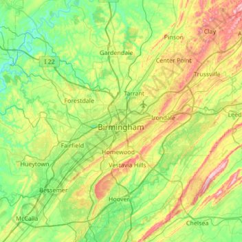
Name: Birmingham topographic map, elevation, terrain.
Location: Birmingham, Jefferson County, Alabama, United States (33.38376 -87.12212 33.67872 -86.57815)
Average elevation: 193 m
Minimum elevation: 79 m
Maximum elevation: 448 m
Other topographic maps
Click on a map to view its topography, its elevation and its terrain.
Windsor Highlands
United States > Alabama > Jefferson County > Homewood > Windsor Highlands
Average elevation: 240 m
Valley Creek
United States > Alabama > Jefferson County > Birmingham > Graymont
Average elevation: 181 m