
Coeur d'Alene topographic map
Interactive map
Click on the map to display elevation.
About this map
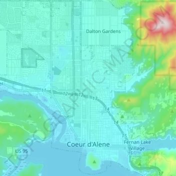
Name: Coeur d'Alene topographic map, elevation, terrain.
Location: Coeur d'Alene, Kootenai County, Idaho, United States (47.65877 -116.85290 47.74484 -116.73145)
Average elevation: 719 m
Minimum elevation: 644 m
Maximum elevation: 1,254 m
Coeur d'Alene is located at 47°41′34″N 116°46′48″W / 47.69278°N 116.78000°W / 47.69278; -116.78000 (47.692845, −116.779910), at an elevation of 2,180 ft (660 m) above sea level. According to the United States Census Bureau, the city has a total area of 16.08 square miles (41.65 km2), of which, 15.57 square miles (40.33 km2) is land and 0.51 square miles (1.32 km2) is water.