
Mostar topographic map
Interactive map
Click on the map to display elevation.
About this map
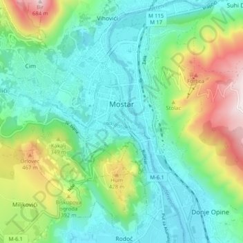
Name: Mostar topographic map, elevation, terrain.
Average elevation: 221 m
Minimum elevation: 37 m
Maximum elevation: 696 m
Other topographic maps
Click on a map to view its topography, its elevation and its terrain.
Mostar
Bosnie-et-Herzégovine > Fédération de Bosnie-et-Herzégovine > Ville de Mostar > Mostar
Mostar, MZ Centar II, Ville de Mostar, Canton d'Herzégovine-Neretva, Fédération de Bosnie-et-Herzégovine, 88000, Bosnie-et-Herzégovine
Average elevation: 602 m
Drvenik
Bosnie-et-Herzégovine > Fédération de Bosnie-et-Herzégovine > Ville de Mostar > Dračevice
Drvenik, Dračevice, Ville de Mostar, Canton d'Herzégovine-Neretva, Fédération de Bosnie-et-Herzégovine, 88201, Bosnie-et-Herzégovine
Average elevation: 453 m