
Grand Chalesme topographic map
Interactive map
Click on the map to display elevation.
About this map
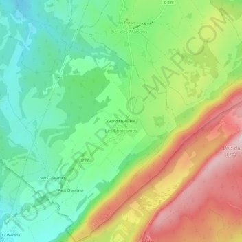
Name: Grand Chalesme topographic map, elevation, terrain.
Average elevation: 960 m
Minimum elevation: 809 m
Maximum elevation: 1,190 m
Other topographic maps
Click on a map to view its topography, its elevation and its terrain.
La Gruyère
France > Bourgogne-Franche-Comté > Jura > Les Chalesmes
La Gruyère, Les Chalesmes, Lons-le-Saunier, Jura, Bourgogne-Franche-Comté, France métropolitaine, 39150, France
Average elevation: 866 m