
Elephant Park topographic map
Interactive map
Click on the map to display elevation.
About this map
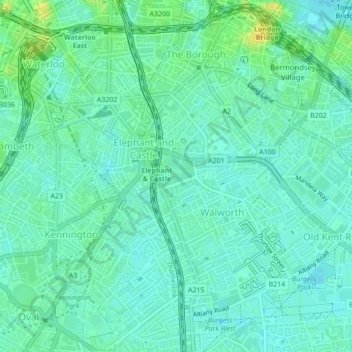
Name: Elephant Park topographic map, elevation, terrain.
Average elevation: 7 m
Minimum elevation: 0 m
Maximum elevation: 23 m
Other topographic maps
Click on a map to view its topography, its elevation and its terrain.
Poulter Park
United Kingdom > England > Greater London > London
Poulter Park, Rosehill, London Borough of Sutton, London, Greater London, England, SM4 6AS, United Kingdom
Average elevation: 31 m
Sunnyhill Park
United Kingdom > England > Greater London > London
Sunnyhill Park, Hendon, London, London Borough of Barnet, Greater London, England, United Kingdom
Average elevation: 62 m