
Make a donation
Gear up for your next adventure:
As an Amazon Associate, this site earns from qualifying purchases at no extra cost to you.
Mouthe topographic map
Click on the map to display elevation.
Make a donation
Gear up for your next adventure:
As an Amazon Associate, this site earns from qualifying purchases at no extra cost to you.
Mouthe
Due to its elevation and its location in a coomb, the diurnal temperature variation is high and Mouthe features a warm-summer humid continental climate (Dfb, according to the Köppen climate classification), with an average annual precipitation of 1,712.9 mm (67.44 in).
Make a donation
Gear up for your next adventure:
As an Amazon Associate, this site earns from qualifying purchases at no extra cost to you.
About this map
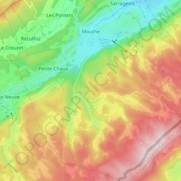
Name: Mouthe topographic map, elevation, terrain.
Average elevation: 1,139 m
Minimum elevation: 921 m
Maximum elevation: 1,410 m
Make a donation
Gear up for your next adventure:
As an Amazon Associate, this site earns from qualifying purchases at no extra cost to you.
Other topographic maps
Click on a map to view its topography, its elevation and its terrain.