
Make a donation
Gear up for your next adventure:
As an Amazon Associate, this site earns from qualifying purchases at no extra cost to you.
Tochal topographic map
Click on the map to display elevation.
Make a donation
Gear up for your next adventure:
As an Amazon Associate, this site earns from qualifying purchases at no extra cost to you.
Tochal
Tochal (Persian: توچال Točāl), is a mountain and ski resort located on the Alborz mountain range, adjacent to the metropolitan area of Tehran in northern Iran. It includes a 12-kilometre-long (7.5 mi) ridge. Its highest peak, also called Tochal, is at an elevation of 3,963 metres (13,002 ft) above sea level.
Make a donation
Gear up for your next adventure:
As an Amazon Associate, this site earns from qualifying purchases at no extra cost to you.
About this map
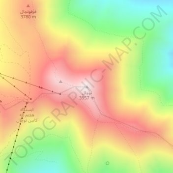
Name: Tochal topographic map, elevation, terrain.
Average elevation: 3,561 m
Minimum elevation: 3,122 m
Maximum elevation: 3,958 m
Make a donation
Gear up for your next adventure:
As an Amazon Associate, this site earns from qualifying purchases at no extra cost to you.