Geolocate

Beverly topographic map

Click on the map to display elevation.

About this map

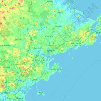
Name: Beverly topographic map, elevation, terrain.

Location: Beverly, Essex County, Massachusetts, 01915, United States (42.39843 -71.04005 42.71843 -70.72005)

Average elevation: 17 m

Minimum elevation: -4 m

Maximum elevation: 115 m

Gear up for your next adventure:

🦶Orthotic Hiking Insoles - Extra arch support for long-distance topographic treks
🎒Hiking Backpacks - Backpacks designed for hiking and trekking
🎽Base Layers - Thermal base layers
🔪Outdoor Multi-tools - Versatile tools for gear repair and survival tasks in the wilderness
🕯️Emergency Whistles - Safety whistles for hiking

As an Amazon Associate, this site earns from qualifying purchases at no extra cost to you.