
Make a donation
Gear up for your next adventure:
As an Amazon Associate, this site earns from qualifying purchases at no extra cost to you.
Lake Eyre (North) topographic map
Click on the map to display elevation.
Make a donation
Gear up for your next adventure:
As an Amazon Associate, this site earns from qualifying purchases at no extra cost to you.
Lake Eyre (North)
The −15 m (−49 ft) altitude usually attributed to Kati Thanda–Lake Eyre refers to the deepest parts of the lake floor, in Belt Bay and the Madigan Gulf. The shoreline lies at −9 m (−30 ft). The lake is the area of maximum deposition of sediment in the Lake Eyre Basin.
Make a donation
Gear up for your next adventure:
As an Amazon Associate, this site earns from qualifying purchases at no extra cost to you.
About this map
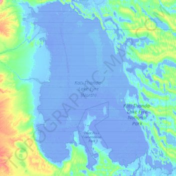
Name: Lake Eyre (North) topographic map, elevation, terrain.
Location: Lake Eyre (North), South Australia, Australia (-29.12493 136.79566 -27.84034 138.06244)
Average elevation: 2 m
Minimum elevation: -21 m
Maximum elevation: 100 m
Make a donation
Gear up for your next adventure:
As an Amazon Associate, this site earns from qualifying purchases at no extra cost to you.
Other topographic maps
Click on a map to view its topography, its elevation and its terrain.