Geolocate

Oleiros topographic map

Interactive map

Click on the map to display elevation.

About this map

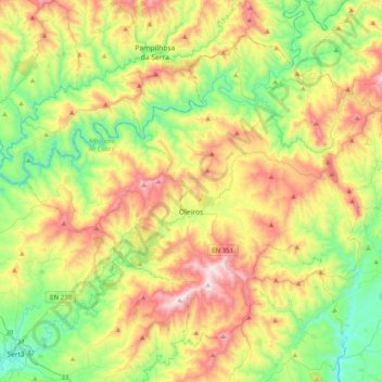
Name: Oleiros topographic map, elevation, terrain.

Location: Oleiros, Castelo Branco, Pinhal Interior Sul, Centro, 6160-152, Portugal (39.81070 -8.08823 40.05915 -7.69109)

Average elevation: 539 m

Minimum elevation: 188 m

Maximum elevation: 1,090 m

Other topographic maps

Click on a map to view its topography, its elevation and its terrain.

Leiria

Portugal > Centro > Leiria

Leiria, Centro, Portugal

Average elevation: 117 m

Guarda

Portugal > Centro

Guarda, Beira Interior Norte, Centro, Portugal

Average elevation: 673 m

Tapadas

Portugal > Centro > Asseiceira

Tapadas, Asseiceira, Tomar, Santarém, Médio Tejo, Centro, 2250-020, Portugal

Average elevation: 132 m

Peniche

Portugal > Centro > Peniche

Peniche, Leiria, Oeste, Centro, Portugal

Average elevation: 3 m

Lisboa

Portugal > Centro

Lisboa, Oeste, Centro, Portugal

Average elevation: 71 m